
|
|
Sunday March 10th 2019 would be another early season chase day, I liked the set-up, it couldn't be ignored so I spent Saturday night and Sunday morning studying the charts. Behind a surging cold front a Wly flow with cold unstable air would advect across the country accompanied by several mesoscale troughs with GFS indicating over 200 ML CAPE. High resolution GFS showed pockets of 500 CAPE and a lifted index of -3 overspreading a large portion of UK and Ireland, the air loft was was a very frigid -40 C and at the surface was a fast flow which meant relatively swift cell motion. Wind shear was present with 10-20 knots over the coast and as much as 50 knots further to the south inland. On Sunday morning I studied the updates, there was no question that I would be chasing, however the question was where would my target area be? Roisin made me a nice fry and I had one final look at the situation, a mess of showery rain was crossing N. Ireland through the morning, I would wait for it to pass through, I needed clearer air behind the mess to allow for solar heating and to catch more discrete cells moving in on the Wly flow. John Fagan had already left for the coast in the morning, I was torn between the same location or inland, I liked the stronger shear inland and there already was thunder in places, however the CAPE would last for longer at the coast and the improved visibility to the horizon would be appealing for storm spotting, John messaged to say that he was seeing improvements with cells appearing in the clearance so I decided I would hit the coast and hook up with him.
 |
I drove from Cookstown to the north coast and finally made it to Benone beach which would be our base of operations for the day, when I pulled onto the beach I saw John already there. Despite the raw wind it was rather nice with sunshine and blue skies, we spotted a large cell forming to the far W which began to rapidly move into view across Donegal, the cell was catching full sunshine and looked a beautiful sight with blue skies and chunky towers pushing up around the base. We decided to shoot a time-lapse, it wouldn't be long before the cell was on us due to the strong steering flow, DSLRs on tripods, cable release in, settings selected and buttons pressed as the cameras began taking a still image every second, we hoped the wind didn't blow them over. This is a still image from the time-lapse sequence, a curtain of hail began to descend and catch the sunshine, moving L to R, the flanking area of this cell extended far beyond the frame to the left, the entire thing would soon be on us.
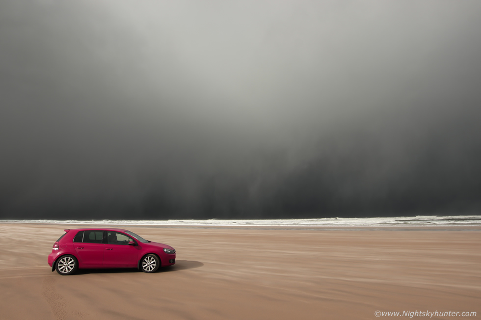 |
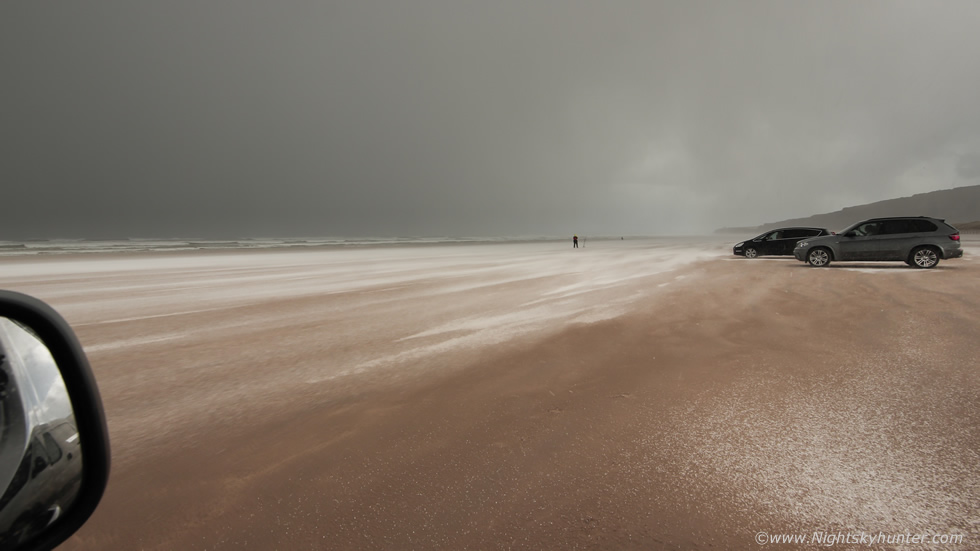
We could feel the wind pick up as loose grains of sand blew across the beach like bizarre sand snakes while a black core of hail had us in its sights, this car pulled up and made for a nice scene contrasting against the dark core of the cell.
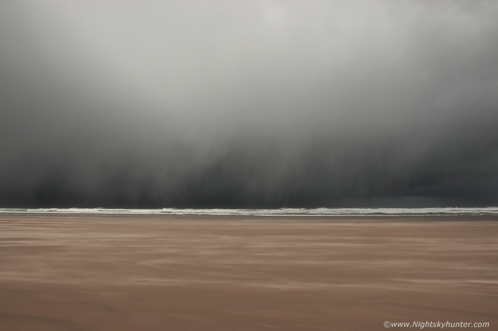 |
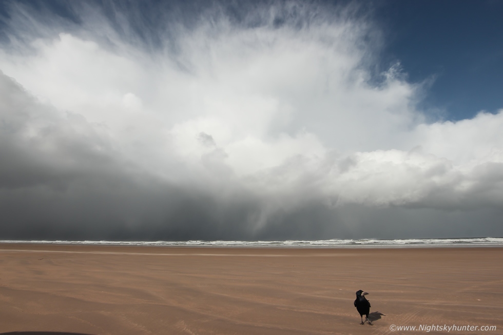
The wind picked up and must have been blowing 25-30mph by this stage. The hail core had now covered much of the skyline with dramatic mottled curtains falling over a black ocean, those curtains were blowing to the right at a swift pace, the temperature began to drop like a stone and the sky turned dark and moody, it looked like a beast was about to swallow us up.
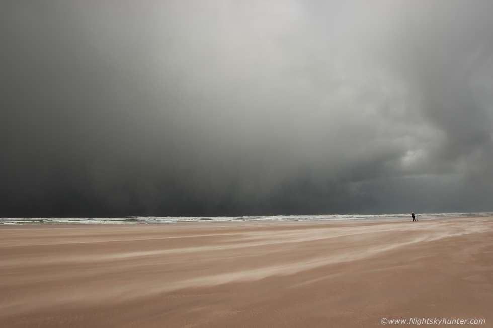 |
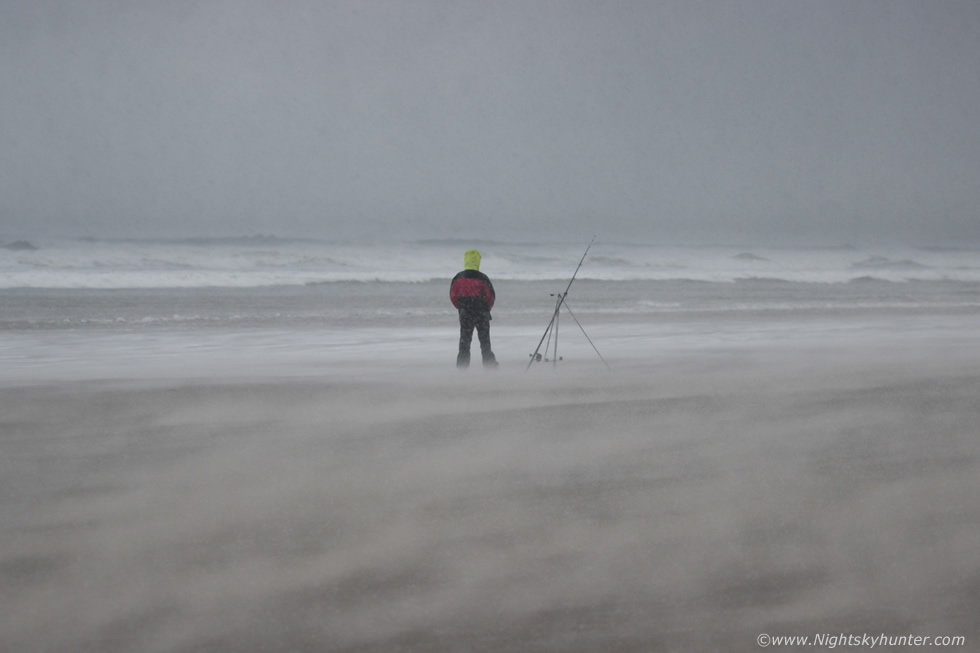
I panned around 90 degrees to the right to get a few final images before we where literally inside the core. A fisherman stood diligently by his rod as the storm bared down, the sand was blowing as if some invisible power hose was at work and I began to get sand particles bouncing off my camera, it was time to take cover.
 |
I jumped in the van, put the diver side window down for one last sneaky image, hailstones had joined in with the sand particles as the wind increased to 40 mph, the clatter of thousands of sand and ice particles could be heard as they swept across the beach which reminded me of tiny class fragments clashing in the wind, this moment was already impressive but I had no idea that this was just the opening act to a severe event about to catch me off guard. The beach turned spectacular, the wind roared and there was a mass of movement outside, the view out the passenger side looked great like a caldron of snakes whirling at high speed towards the van, I chanced my luck and put down that window and began recording video, approximately 10 seconds later the dynamics of the atmosphere changed in an instant. The hailstones and sand crystals merged into a blinding smoke machine of debris which began whipping into the van at tremendous speed, the inside of the van was slammed by hail and sand, covering the dash, into the camera, all over the seats, and biting into my face and eyes, the wind lashed me and took my breath away, I put the window back up and turned around and resumed filming out the driver's side.
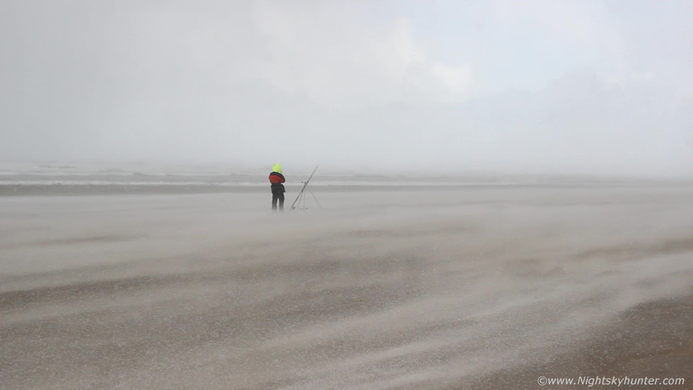 |
Beach life turned crazy, severe winds whipped across Benone blasting everything with hailstones and sand particles, the combination of the two elements made for a terrific sight like a river of ice shearing the sand. The Foyle buoy was now recording a sustained wind gust of 58.6mph and ATD sferics confirmed lighting strikes over Donegal as it arrived, this was a severe thunderstorm and we where perfectly positioned inside the precip core. One of the criteria a severe thunderstorm is based upon is the speed of wind gusts associated with the storm's outflow. 58mph meets severe criteria in the USA whereas in the UK its 55mph. The following two images are video grabs taken from the footage, the downdraught from this storm was amazing, I wanted to yell with excitement and delight however I was too fixated on trying to get good footage so I concentrated on holding the camera as steady as I could despite the shaking van. The fisherman held his ground as he experienced the full onslaught of the storm's cargo of hail, sea spray and sand crystals traveling across the beach at almost 60mph.
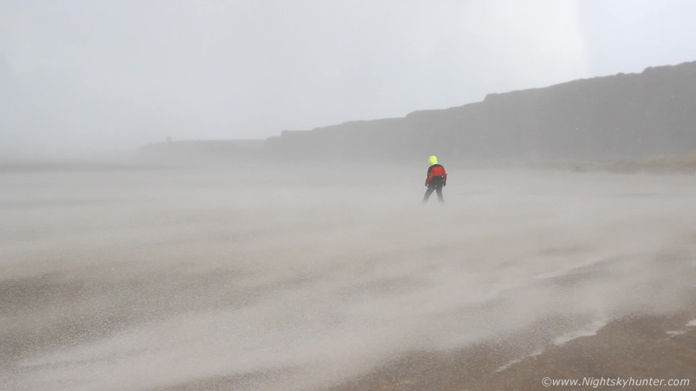 |
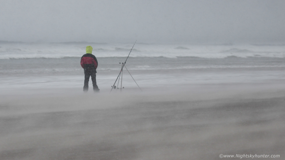
The powerful squall almost caused white out conditions as hailstones merged into a high velocity white fog, even the fisherman made his way back to his car for shelter. I stole a look across to John's van and there he was focused on filming just as I was, we were both in the zone and loving it.
 |
Satisfied that I had captured the most severe sequence on video I switched to manual and shot several stills, the fisherman was back in action, we both thought that he was a complete savage for sticking out that squall to keep an eye on his rod, it was cool but also comical, he made for great foreground interest and subject matter for our footage as the sand snakes twisted around him.
 |
After five minutes the wind eased down as the cell moved eastward and the sun had come back out over Benone beach once more. John and I were buzzing, we couldn't believe we had just experienced the downdraught and associated outflow from a severe thunderstorm this day, none of us expected this, the footage of this rare transient event associated with a convective cell had made the three hour round trip more than worth it. We kept watching the skies and documenting more cells until sunset then I called it a day, I began the drive back to Cookstown, while passing Moneymore I saw the anvil of a large cell in the twilight near the waxing gibbous moon, it made for a great sight however rain and my growing hunger made me drive on. I later learned it had lit up the sky soon after that with lightning over the north coast, however I didn't mind, my thoughts were happy and content with the severe outflow event I had experienced earlier, it was a keeper. I arrived home to a wonderful homemade chicken curry dinner made by Roisin which tasted like heaven.
Full video footage of the approaching storm with short time-lapse sequence then the full onslaught of the severe thunderstorm downdraught across the beach, make sure to turn up your volume and watch at 1080p in a new window for the best experience, thanks very much for reading.
Martin McKenna